Category Archives: Planning

Do Honolulu’s transit planners actually ride TheBus?

Civil Beat’s most popular story yesterday started to shine a much-needed bit of light on Honolulu’s once stellar bus system (“Honolulu Traffic Is Terrible. So Why Aren’t More People Riding TheBus?”).

Marcel Honore looked at various responses to declining ridership. Lower bus fares. A modern payment system using smart cards or smart phones. Adding doors on the left side for expediting boarding and departing on one-way streets. Dedicated bus lanes on certain streets.

Those are all interesting moves.

But if you’re wondering why ridership is down, you have to ride Honolulu’s buses. Buses on main routes are all too often crowded to the “standing room only” point at various times of the day. And if you find yourself standing, you know that our buses are particularly cramped, with narrow aisles that make moving through a crowded bus difficult and uncomfortable.

Does TheBus collect data on how crowded its buses are as they travel along their routes? We have good data on the movement of traffic that allows identifying intersections that need reengineering. Does the city have similar data to identify particularly troublesome bus routes are most crowded?

And how about those bus stops. Shelters from the sun and rain at bus stops are getting rare. And attempts to make them unusable by the homeless make them equally unfriendly to bus riders. On the windward side, where rain is a fact of life, the absence or disrepair of bus shelters is an ongoing fact-of-life.

I often wonder whether those who make transit decisions are required to ride the bus to and from work at least some of the time, or get across town for meetings during the work day. It might make a difference in how they think about such things.

For a number of years, Portland (Oregon) had a “fareless square” in the downtown area where transit was free. If we really want to get people out of their cars, reducing fares closer to zero would certainly be an answer.

Check the Wikipedia entry for “Free Public Transport.”

Free public transport, often called fare-free public transit or zero-fare public transport, refers to public transport funded in full by means other than by collecting fares from passengers. It may be funded by national, regional or local government through taxation, or by commercial sponsorship by businesses. Alternatively, the concept of “free-ness” may take other forms, such as no-fare access via a card which may or may not be paid for in its entirety by the user. Luxembourg is set to be the first country in the world to make all public transport free[1] from 1 March 2020.[2] Germany is considering making their public transit system fare-free in response to the EU’s threatening to fine them for their air pollution levels.

Perhaps making all or part of Honolulu’s bus system free would do more to boost ridership and ease traffic congestion than fiddling with little design changes.

Perhaps bus riders can submit reviews of some of their rides to provide a more complete perspective on TheBus.

What about those “perfectly legal” campaign contributions?

My post here on Saturday regarding the controversial proposal for a children’s playground in a section of Ala Moana Park drew a number of comments.

One comment yesterday by someone using the name “Foggy Bottom” was critical of my focus on legal campaign contributions associated with the officers of the nonprofit group that has pushed the playground proposal.

Here’s an excerpt which gives the flavor of the comment.

Yeah….good job Ian. Just maybe the SA didn’t dive into the “follow the money” trail because the newspaper doesn’t report on perfectly legal political donations made by people who can?

The commenter is absolutely right that these contributions were “perfectly legal.”

It does not, however, follow that they are not a legitimate matter of concern and public scrutiny. This is, after all, a small local example of why the role that money has assumed in our system of elections and governing is of such widespread public concern.

Other commenters point out the playground proposal was developed behind the scenes in direct discussions between the nonprofit group, Paani Kakou, and the city, without the benefit of normal public review and feedback, and “wasn’t a part of the EIS that got studied and evaluated.”

And they have raised additional questions about the appropriateness of the location and design, the cost of ongoing operation and maintenance, as well as thorny issues stemming from the potentially conflicting interests of the public and the city’s private nonprofit partner.

One other key issue, it seems to me, is whether such a planning process was possible only because elected or appointed public officials gave special deference to the views or proposals of this tight group, all connected to the Park Lane development, who had all made substantial but “perfectly legal” campaign contributions to the mayor and members of the city council.

At least one applicable law is the “fair treatment” provision of the city’s ethics code, part of the Honolulu City Charter.

Section 11-104. Fair and Equal Treatment —

Elected or appointed officers or employees shall not use their official positions to secure or grant special consideration, treatment, advantage, privilege or exemption to themselves or any person beyond that which is available to every other person. (Reso. 83?357)

The same provision is part of the state ethics code as well. It would be informative to take a look at how this has been applied and construed in the past, but that’s something for another day.

For now, it just stands as a reminder that bending normal procedures to provide “special consideration, treatment, advantage, privilege or exemption” to campaign supporters or any other person is legitimately a matter for public scrutiny.

Can we empower real community-based planning?

After living in Kaaawa for most of three decades, we watched the whole process of pseudo community consultation carried out by government planners and decision-makers time and again. Even when strong community sentiment was clearly expressed, it was more often than not ignored or minimized.

I think Lee Cataluna got it right in her Honolulu Star-Advertiser column last week.

Oh, sure, politicians and “community engagement professionals” representing various development projects will hold meetings in a school cafeteria a couple of times before the construction vehicles start rolling. They’ll have serious looking people in reverse-print aloha shirts sitting impassively through hours of testimony and earnest pleas.

They may even call these meetings “listening sessions,” which means that they won’t answer any questions, and then they’ll go ahead and do whatever they planned to do all along, though perhaps they’ll write a check to a community organization or an after-school program to try to buy some acquiescence. It’s too often about quelling the voices of opposition, not giving them credence.

But community members — moms and dads who work all day at jobs they don’t even like just to afford to live in the same town where they grew up, grandparents who worked hard all their lives thinking of the future, grandparents who are spending their retirement years raising their grandchildren, people who just want to go about their lives without undue burdens — they don’t feel heard. Listening is not hearing. Truly hearing the voices of the community means taking the messages to heart and being open to changing plans or waiting until all questions are addressed.

At the base of the problem is that it’s either a state or county agency, or a private developer, that has the resources to hire an army of planners, and then direct their plan towards their desired outcome. The community, on the other hand, usually doesn’t have a unified voice and almost certainly won’t have the resources to hire their own planners and researchers to refine and sharpen their critique.

One result is that communities are on the defensive from the start, having to find errors in what the developers propose rather than being able to shape their own plans from the beginning.

I recall a story told by friends a number of years ago. They were very proud of their son, who had a brand new law degree and was on the job market. During an interview for a local government position, the interviewer posed a hypothetical question. Something like this—“So there’s a controversial development project that has generated community protests, and you’re assigned to check out the legal issues. What would you do?”

So their son thought about it, and explained that he would interview key community members to understand what was behind their complaints, and then look at how the project could be changed to reasonably accommodate the community concerns.

Before he could elaborate, the interviewer cut him off. ”No,” he explained. “You would make it come out right.” Meaning, of course, that he would find reasons that the development as proposed was the best course of action and the community complaints unfounded.

That story is either literally true or, possibly, simply expresses a cynical view of how these planning processes really work, one based in past experience.

Now we have a number of communities up in arms, from the TMT to Kahuku, in situations where the planning process ended up obtaining all the necessary permits and approvals, but obviously failed to identify and accommate serious community concerns, leading to late-stage protests at the point where serious money has been invested and changes, even if justified, are very difficult to make.

Under current law, where an environmental impact statement is required, it is the developer or agency proposing the underlying project that hires the consultants and directs their work. Often, it could be argued, proceeding with that “make it come out right” approach.

What if the law required the affected communities to be provided the resources to hire their own planners and consultants early in the planning process?

Those agencies that have to approve permits would have the benefit of a fuller factual base to work with, communities would have a clearer voice, the likelihood of litigation would hopefully be reduced, and the public would get better results.

Of course, there would have to be criteria for determining which development plans, and which communities, would qualify to receive these planning resources, but that’s not a huge hurdle.

Looking at the costs of failed planning for Honolulu’s rail, for the TMT, for those giant wind turbines standing over 600 feet tall over Kahuku, the costs of empowering community planning seem more reasonable by comparison.

TMT in perspective

Let me try to put the proposed Thirty Meter Telescope (TMT) in perspective, using data from the TMT project EIS and the Supreme Court’s 2018 decision allowing the project to go forward.

Most of the Mauna Kea summit is within what is designated as the Mauna Kea Science Reserve, which consists of 11,228 acres, surrounded largely by forest reserve.

The bulk (95%) of the total is designated a Cultural and Nature Preservation area consisting of 10,763 acres.

The Astronomy Precinct makes up the remaining 525 acres (about 5% of the total).

And the total area of the proposed TMT, including the observatory dome, support building, and the area disturbed during construction would be about five acres.

Here’s a chart showing the relative sizes. The first column, on the left, represents the entire area set aside as the Mauna Kea Science Reserve. The second column represents what is part of the Cultural and Natural Preserve. The third column shows the relative size of the astronomy precinct. And, finally the last bar represents the size of the TMT site.

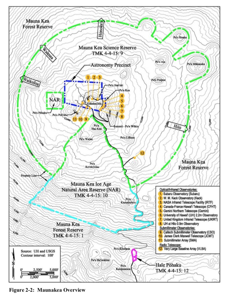
Here’s an overview from the EIS. The Mauna Kea Science Reserve is outlined by the green dotted line. The smaller Astronomy Precinct is outlined by the dotted blue line.

And one more graphic, this time a closer look at the location of the TMT site. The Astronomy Precinct is shown by the dotted blue line. The Astronomy Precinct is divided into five zones, marked as Area A through Area E. The latter, Area E, is in the upper portion of the Astronomy Precinct marked by the red dotted line.

The TMT site is shown in yellow, located in the upper section of Area E. The actual observatory would be in a portion of the area shown in yellow.

The TMT site is located 600 feet below the summit ridge, according to the EIS. The observatory would rise 180 feet above ground, leaving the top of the observatory more than 400 feet below the summit ridge.

Links to the draft environmental impact statement can be found here.