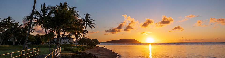
 While most of the week was cloudy and wet, one morning provided a clear view of Molokai and beyond as the sun rose in Kaaawa.
These clear mornings always prompt further questions and disputes. What exactly are we seeing?
I’ve been through several cycles of such questions and have gathered several useful hints through the years.
The curvature of the earth is a big factor when viewing from sea level, as we do. I took a look at the calculations back in 2004 and decided we are probably seeing Molokai with Haleakala in the background. Unfortunately, the link to a chart of distances between the islands no longer works, and I couldn’t find a quick substitute.
The next day, I displayed two photos side by side showing in which the shapes of the islands was different.
Then there was a view from Bellows offering up different clues. From that angle, you can see that the shape on the right, seen in the earlier photos, is made up of one island closer to us superimposed on another farther away. My guess–the lower west end of Molokai with Haleakala in the background, or perhaps it is the West Maui Mountains with Haleakala behind. The Bellows perspective may also show the tip of Lanai on the far right.
Finally, a took a look at a nautical chart, which may or may not clarify the situation.
I don’t know that I’ve gotten a definitive answer, but it’s been fun getting this far.
Discover more from i L i n d
Subscribe to get the latest posts sent to your email.
that’s pretty cool; migrating islands.
A stretched piece of string? Well, at least you’re on the right track…
Ask a bored/curious civil engineer (or perhaps hire a furloughed one…) to haul out a transit and measure those azimuths and elevations. That would settle the matter.
I think it‘s most likely just clouds. We often see the same type of thing from the beach on the horizon here on Kaua`i when the weather conditions and light are just right. It often looks so darn real the only way we know it’s not really land is that there just aren’t any other islands in that direction that we could possibly see except for a tiny bit of the NW shore of O`ahu and then only at very high elevations.
The Bellows picture shows West Moloka’i, Puu Nana right under Haleakala. Haleakala does have those cinder cones that are seen in your first picture. Also Mauna Kea is seen in the Bellows picture off to the west I think. When I worked at KIKI in the 80’s we could occasionally see Haleakala over the Kaimuki rise at sunrise from the 17th floor of the Davies Pacific Center.