
Scanning old snapshots after removing them from the plastic sleeves in large blue binders takes much longer than it should because, of course, I look at the photos and all too often get distracted something or another.
This seems to lead me to go wandering off onto tangents where the foibles of decades-old memories have to be corrected with a bit of investigative effort. Luckily, I’m mostly retired and free to go off on tangents, which can also be opportunities to learn something.
Here’s a simple–or perhaps a not so simple–example. I’m sorry the post is a little long, but I kind of got into explaining the process it required to get the job done.
I just finished scanning another several hundred photos from 1997, easy to date because some are stamped on the picture by the camera when it was taken, others have a date added on the back when printed, and still others are not dated but obviously fit in the dated sequence.
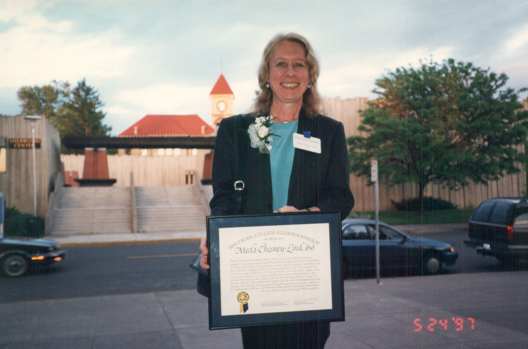
Alumna of Merit
There are about 100 photos documenting the trip from beginning to end, and I can identify where each was taken, except for one.
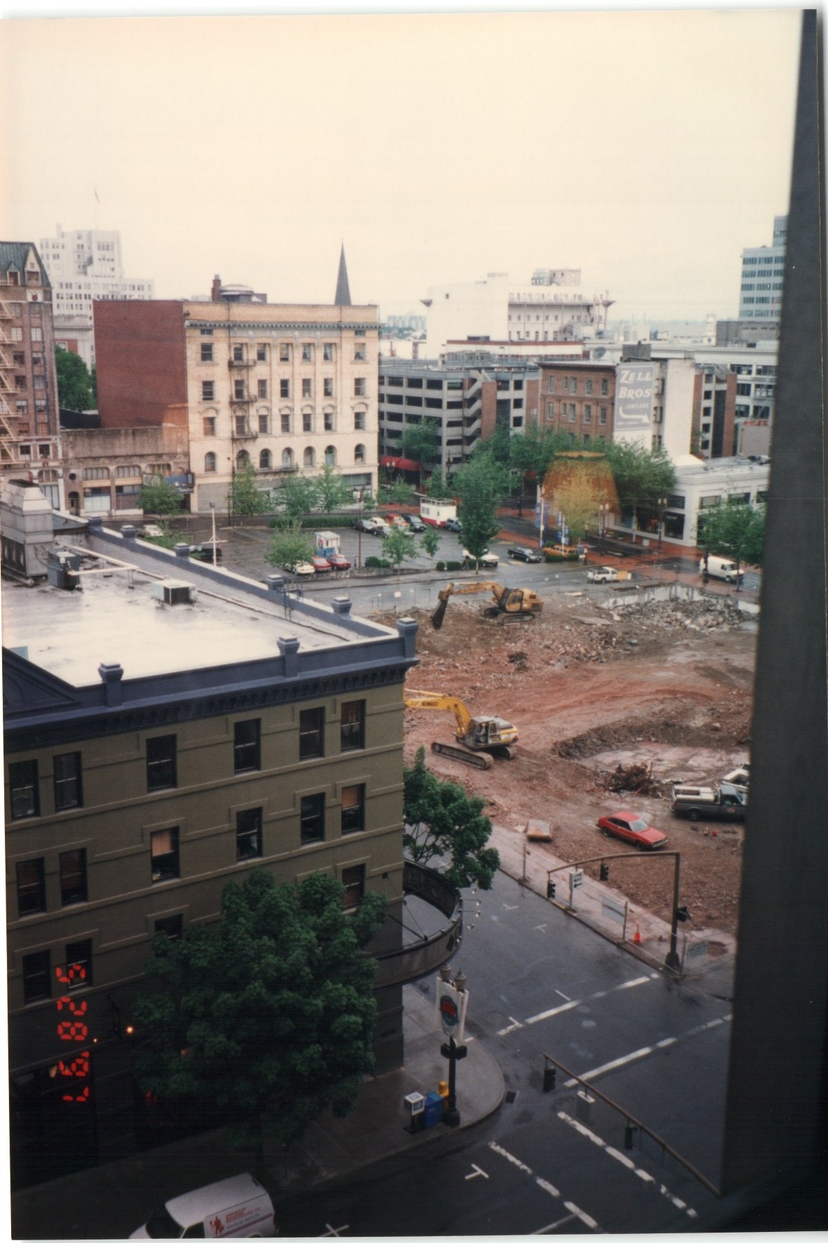 It’s an urban scene, apparently in downtown Portland. A number of buildings and streets look vaguely familiar but I can’t specifically place them. Somehow this drew my attention, and I set out to find where the picture was taken.
There are several clues in the photo. There’s a sharp spire visible over a building in the center. Faded lettering can be seen on another building, “Zell Bros” with an arrow pointing down. There is a large area, perhaps a whole city block, where preliminary site work is being done for a major construction project. And at the bottom of the mystery photo, the building on the corner across the street has an unusual curved sign.
The photo appears to have been taken from a high rise building, most likely the hotel where we were staying.
Not too much to go on, but I know a bit about online sleuthing, so off I went.
The first step was to upload the mystery photo to Google, and then use Google Lens to search its memory banks for the scene. I’ve had about a 50% success rate on previous searches of this kind, so it’s always a good starting point.
Within seconds, Google returned an answer, but it was incorrect on its face.
According to Google:
The image provided, dated August 28, 1997 (8.28.97), shows a construction or demolition site in Seattle, Washington, likely the future location of the Civic Square development.
The site, located between Third and Fourth avenues and James and Cherry streets across from Seattle City Hall, was the former location of the Seattle Public Safety Building, which was demolished in 2005.
Google had the wrong city, and the wrong time frame (2005 instead of 1997).
My next step was to locate the hotels where we’ve previously stayed in Portland, and check the surrounding areas looking for a nearby building that might have been starting construction back in 1997.
We’ve spent a lot of time in Portland over the years, and are pretty familiar with parts of the city, including the downtown area. Meda’s family moved to Portland when she was starting high school, and after we got married we returned frequently to visit her mother, who had by then moved to a home in the Southwest Hills. Many days we would ride the bus from up in the hills down into the center city, and just wander around. Her brother still lives in Portland, along with several old friends, so we have continued to return once or twice a year.
I did recall we had stayed in several different hotels over the years. University Place, on Lincoln Street on the edge of the Portland State University campus. The Marriott Center City (or was it City Center?), now renamed the Marriott Bidwell, on Broadway. The Duniway on 6th Avenue. And the former Westin, now the Dossier Hotel, on Alder Street and Park. The Paramount, on Taylor and Park. And after interrogating my memory for a while, I finally remembered staying at a Four Points Sheraton on Morrison near 1st Street, which is now known as Hotel Rose.
A quick look at the area surrounding each hotel using Google maps didn’t produce any “aha” moments, but then I returned to the Google photo search results and looked beyond its AI summary to examine photos of potential matches it offered up.
And one of those photos showed a large excavation identified as the future site of the Fox Tower, a 27 or 28-story commercial building across Broadway from Pioneer Courthouse Square. It’s ground floor is home to a Regal 10-theater complex.
A separate search found the new Fox Tower opened in 2000, so preliminary site work could easily have been underway in mid-1997.
And, most important, the building site is just across the street from the Paramount Hotel, one of the places we’ve stayed.
I was getting close, but examining the photo, and comparing it to a map of the area, showed it couldn’t have been taken from the Paramount after all.
I was venting about this inconsistency when Meda added a new wrinkle by telling me we had stayed at the Portland Hilton once or twice.
Aha! Although the Hilton wasn’t one of the hotels I remembered, it the last piece needed to complete the puzzle.
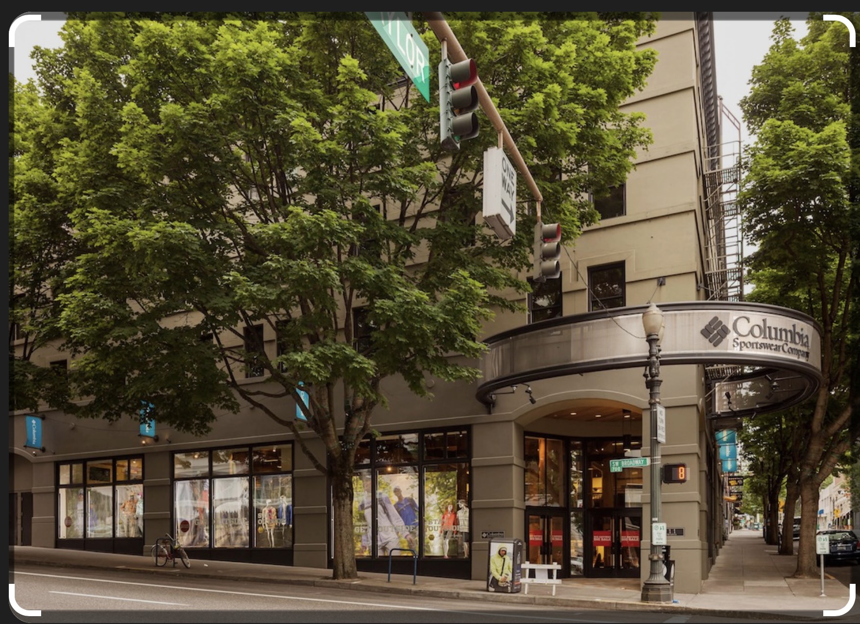
The photo, is seems, was taken from our room at the Hilton which looked out onto the corner of SW Taylor and Broadway. All the angles suddenly made sense, as we looked across to the construction site for Fox Tower, on the opposite side of Taylor Street.
And two more clues also fell into place, confirming the view is from the Hilton.
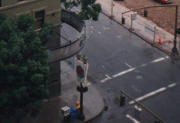
Screenshot
And that spire which shows up in the mystery photo? It turns out to be part of the First Presbyterian Church at the corner of SW 12th and Morrison. Right in the line of sight from the Hilton.
So finally all the pieces of the puzzle have fallen into place. Mystery solved.
Whew.
Discover more from i L i n d
Subscribe to get the latest posts sent to your email.